HORIZON INTERNATIONAL SOLUTIONS SITE
Working to Find and advance solutions to environment, health, poverty, and development problems
Water is a precious resource many take for granted until there is too little or too much. Scientists and engineers have positioned instruments at the Susquehanna Shale Hills Observatory at Pennsylvania State University to learn much more about the water cycle there. It is one of six Critical Zone Observatories in the United States.
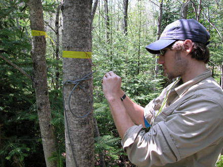 |
| Researchers wanted to know if trees closer to the wetland used more water than ones that were further away. To figure this out, they picked 150 trees and, by putting sensors into the tree-trunks, measured how much water each one used. Photograph by D. Scott Mackay, SUNY Buffalo courtesy of Science Nation, National Science Foundation . |
Water is a precious resource many take for granted until there is too little or too much. Scientists and engineers have positioned instruments at the Susquehanna Shale Hills Observatory at Pennsylvania State University to learn much more about the water cycle there. It is one of six Critical Zone Observatories in the United States.
"What we're trying to do is build experimental test beds across the United States and we're also working with several European Critical Zone Observatory test beds, to understand the cycle of water in detail," says Chris Duffy, a professor of civil and environmental engineering at Penn State.
With support from the National Science Foundation (NSF), Duffy and his team are documenting the flow of water at the forested Shale Hills watershed from rain and snow through plants, soil and rock--from "bedrock to boundary layer."
"We have very sophisticated sensors at Shale Hills," explains Duffy. "We use things like laser precipitation monitors. They're infrared lasers that measure droplets; in fact, [they] tell us the type and amount of rainfall, whether it's rain or snow or sleet, and allow us to get accurate numbers on the incoming rainfall."
Little water can escape unnoticed. Instruments poised atop a tall tower at Shale Hills measure water as it evaporates. "Water vapor that's leaving the watershed and going into the atmosphere is captured by those sensors," says Ken Davis, a professor of meteorology at Penn State.
Davis points to two of the many instruments attached to the tall structure. "One measures the wind and temperature, and the other measures water vapor and carbon dioxide concentration in the atmosphere. We actually measure all the individual updrafts and downdrafts of air as they leave the surface and then come down from the upper atmosphere. Understanding how the earth processes water is important for drought and flood forecasting," explains Davis.
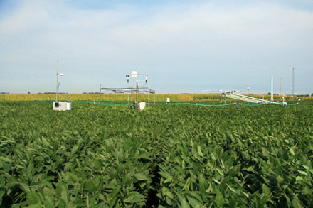 |
| Energy researchers and environmental advocates are excited about the prospect of gaining more efficient large-scale biofuel production by using large grasses like miscanthus or switchgrass rather than corn. They have investigated yields, land use, economics and more, but one key factor of agriculture has been overlooked: water. Photograph by Praveen Kumar courtesy of Science Nation, National Science Foundation . |
The team is also perfecting a way to fingerprint the water from individual storm events by using natural tracers to identify the pathways of storm water through the watershed. This has helped the researchers determine that in an average year, most of the annual water supply in streams actually comes from winter snow rather than summer rainfall.
"What we're using is oxygen-18 and deuterium, two isotopes of water. Both are components of water molecules," says Duffy. "By taking samples to the laboratory and making these measurements, we are able to trace this signature from rainfall to vegetation to soil water to stream flow and determine how long the water spent in the watershed."
Another device called a sap flow sensor, attached to trees, measures the rate water moves through the wood of the tree and up to the leaves. It's no surprise that plants are huge water guzzlers.
"Usually, it's the largest fraction of water that leaves this watershed," says David Eissenstat, professor of woody plant physiology at Penn State. "When you're working with trees, it's hard to measure all the water being transpired from water vapor in the air."
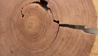 |
| David Stahle, director of the Tree Ring Laboratory at the University of Arkansas, along with colleagues from the National Laboratory of Dendrochronology at the Mexican Forest Research Institute, collects tree-ring samples from remote forests, far from human influence. Stahle is now developing tree-ring records of Mexico's climate variability. Photograph by Praveen Kumar courtesy of Science Nation, National Science Foundation |
That is why researchers like Katie Gaines will climb trees to collect leaves and branches to sleuth out sources of water trees use.
"We climb up and we get these branch samples. We put them into vials and seal them up so that we can take them back to the lab, take the water out of them to get an idea where the water in the tree actually came from," explains Gaines. The researchers do this to measure how deep roots of plants and trees go to meet their water demands.
Geology plays a big part. The type of soil and rock under the observatory determines how much of the water will flow into streams and how much will seep into an underground basin.
"We measure the moisture content that's stored in the soil at different depths and at different times of the year so we'll know how the soil will respond to the rainfall," says soil scientist and hydrologist Henry Lin. "We want to know how much water is retained in the soil to support plant growth and groundwater and how much might run down the hill to the stream."
The scientists also have instruments within the soil to measure how the water changes throughout its journey. Hydrogeologist Kamini Singha says they want to answer a number of questions as they follow the flow of water through soil and rock. "How long does it take for water to migrate through the system? Does it have a chance to clean itself as it moves? Is it picking up material as it goes? So, some understanding of what water does in the subsurface is important to all of us," she says.
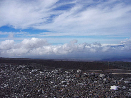 |
| With its sea turtles and surf shops, the Big Island of Hawaii resembles a tropical, watery world. Yet for climate scientists, it's the ideal place to study low-humidity air and the processes that dehydrate the atmosphere. Photograph by CIRES, University of Colorado at Boulder courtesy of Science Nation, National Science Foundation |
Duffy says a key goal is to understand the water cycle well enough to help planners better predict the impact of floods, droughts and reliability of water supplies because "global change and global warming is accelerating climate effects, increasing rainfall in some areas and increasing drought impacts in other areas."
Miles O'Brien, Science Nation Correspondent
Ann Kellan , Science Nation Producer
This article is courtesy of Science Nation, National Science Foundation (NSF), 24 October 2011
Related Links from Science Nation:
The Division of Earth Sciences (EAR) of the Directorate for Geosciences supports research geared toward improving the understanding of the structure, composition, and evolution of the Earth, the life it supports, and the processes that govern the formation and behavior of the Earth's materials.
Pacific Northwest Trees Struggle for Water While Standing in It
Researchers have discovered that the conifers of the Pacific Northwest, some of the tallest trees in the world, face their greatest water stress during the region’s eternally wet winters.
Kent State Geology Professor and Research Team Present Findings Studying Drought
A group of researchers has studied the history of drought in the Pacific Northwest during the last 6,000 years. The research extended the drought history of the Pacific Northwest back much longer than the tree ring record, which provides information in the region over the past 1,500 years.
Desert Dust Alters Ecology of Colorado Alpine Meadows
Accelerated snowmelt--precipitated by desert dust blowing into the mountains--changes how alpine plants respond to seasonal climate cues that regulate their life cycles, according to results of a study reported in 2009.
NSF Grants for Three Critical Zone Observatories
In 2007, NSF selected sites for three critical zone observatories (CZO). The three are located in watersheds in the Sierra Nevada, the Front Range of the Colorado Rockies, and the Appalachian Uplands. Scientists at each CZO will investigate the integration and coupling of Earth surface processes and how they are affected by the presence and flux of fresh water.
Want to Understand Drought? Follow the Water!