HORIZON INTERNATIONAL SOLUTIONS SITE
Working to Find and advance solutions to environment, health, poverty, and development problems
By designating these areas as national monuments, the Administration ensures that the marine environment will receive the highest level of environmental recognition and conservation.
By designating these areas as national monuments, the Administration ensures that the marine environment will receive the highest level of environmental recognition and conservation. Destruction or extraction of protected resources within the boundaries of these monuments will be prohibited, as will commercial fishing in the coral reef ecosystem areas of the monuments. Scientific and recreational activities may be permitted consistent with the care and management of the protected resources of these monuments. For marine life and seabirds, these places will be sanctuaries to grow and thrive. President George W. Bush
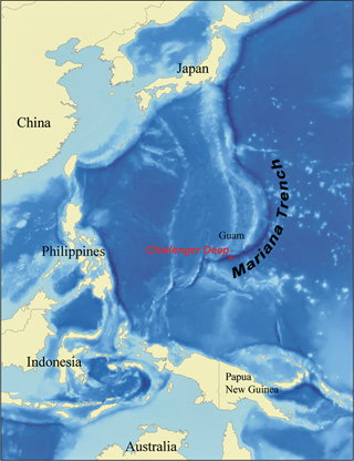 |
| Mariana Trench The Mariana Trench is approximately 940 nautical miles long and 38 nautical miles wide within the United States Exclusive Economic Zone and contains the deepest known points in the global ocean. Photo: NOAA |
Combined, these designations represent the largest fully protected area in the world.
Under the President's plan, 195,274* square miles will be conserved. In 2006, President Bush established the Northwestern Hawaiian Islands Marine National Monument with nearly 140,000 square miles bringing the protected Pacific areas to about 335,000 square miles.
Briefly summarized:
The Marianas Trench Marine National Monument consists of three components:
 |
| NASA NLT Landsat7 Satellite Image of Johnston Atoll, Pacific Ocean |
The Pacific Remote Islands Marine National Monuments protects the pristine coral reef ecosystems around Kingman Reef, Palmyra Atoll, Howland, Baker, and Jarvis Islands, Johnston Atoll, and Wake Island.
These areas support a large number of nesting seabirds and migratory shorebirds, and their pristine coral reefs contain hundreds of thriving fish species and large apex predators and are also home to endangered turtles.
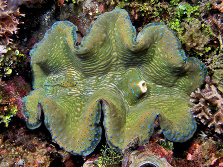 |
| Green and blue giant clam from East Timor Photo: Nhobgood from Wikipedia |
The Rose Atoll Marine National Monument protects the pristine coral reef ecosystem around a remote part of American Samoa. One of its most striking features is the pink hue of fringing reef caused by the dominance of reef building coralline algae. Rare species of nesting petrel, shearwaters, and terns also thrive on this island, and the waters surrounding it are a home for many species depleted elsewhere in the world, including giant clams and reef sharks.
About the Marine National Monuments:
The Marianas Trench Marine National Monument
Over approximately 480 nautical miles, the Mariana Archipelago encompasses the 14 islands of the United States Commonwealth of the Northern Mariana Islands and the United States Territory of Guam that sit atop the Mariana Ridge in an area known as the Mariana Volcanic Arc. The Mariana Volcanic Arc is part of a subduction system in which the Pacific Plate plunges beneath the Philippine Sea Plate and into the Earth's mantle, creating the Mariana Trench. Six of the archipelago's islands have been volcanically active in historic times, and numerous seamounts along the Mariana Ridge are volcanically or hydrothermically active.
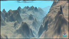 |
| Mariana Trench Dive Animation These animations were produced by Dr. Peter Sloss of NOAA's National Geophysical Data Center (NGDC), Marine Geology and Geophysics Division, from actual digital bathymetric data archived by, and available through NGDC. Photo: NOAA National Geophysical Data Center (NGDC) |
Mariana Trench Dive Animation: The Mariana Trench may be the deepest place in the world's oceans, but these videos have the vertical dimension strongly exaggerated to further enhance the visual effect. The maximum depth of the trench is a little greater than 11 kilometers, but its width is over 50 kilometers. The color scheme chosen is arbitrary but represents a typical color for the ocean bottom.
The Mariana Volcanic Arc contains objects of scientific interest, including the largest active mud volcanoes on Earth. The Champagne vent, located at the Eifuku submarine volcano, produces almost pure liquid carbon dioxide. This phenomenon has only been observed at one other site in the world. The Sulfur Cauldron, a pool of liquid sulfur, is found at the Daikoku submarine volcano. The only other known location of molten sulfur is on Io, a moon of Jupiter.
The waters of the archipelago's northern islands are among the most biologically diverse in the Western Pacific and include the greatest diversity of seamount and hydrothermal vent life yet discovered. These volcanic islands are ringed by coral ecosystems with very high numbers of apex predators (those predators that are not preyed upon as healthy adults in the wild), including large numbers of sharks.
 |
| The deep stony coral reef off the island of Maui, which may be the deepest known reef in the US. Image courtesy of Tony Montgomery, HI Division of Aquatic Resources. |
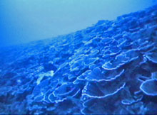
They also contain one of the most diverse collections of stony corals in the Western Pacific. The northern islands and shoals in the archipelago have substantially higher large fish biomass, including apex predators, than the southern islands and Guam. The waters of Farallon de Pajaros (also known as Uracas), Maug, and Asuncion support some of the largest biomass of reef fishes in the Mariana Archipelago. These relatively pristine coral reef ecosystems are objects of scientific interest and essential to the long-term study of tropical marine ecosystems.
The Federal land and interests in land reserved consists of approximately 95,216 square miles of submerged lands and waters of the Mariana Archipelago, which is the smallest area compatible with the proper care and management of the objects to be protected.
Submerged lands that by legislation are subsequently granted by the United States to the Commonwealth of the Northern Mariana Islands but remain controlled by the United States under the Antiquities Act may remain part of the monument, for coordination of management with the Government of the Commonwealth of the Northern Mariana Islands. Any submerged lands and interests in submerged lands within the monument not owned or controlled by the United States shall be reserved as a part of the monument upon acquisition of title or control by the United States.
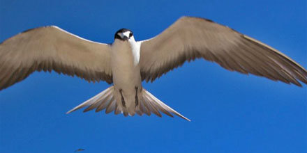 |
| Sooty Tern Onychoprion fuscatus Taken on Lord Howe Island, Australia Photo by Glen Fergus, Wikipedia |
The Pacific Remote Islands Marine National Monument
The Pacific Remote Islands area consists of Wake, Baker, Howland, and Jarvis Islands, Johnston Atoll, Kingman Reef, and Palmyra Atoll, which lie to the south and west of Hawaii. With the exception of Wake Island, these islands are administered as National Wildlife Refuges by the United States Fish and Wildlife Service of the Department of the Interior.
These refuges are an important part of the most widespread collection of marine- and terrestrial-life protected areas on the planet under a single country's jurisdiction. They sustain many endemic species including corals, fish, shellfish, marine mammals, seabirds, water birds, land birds, insects, and vegetation not found elsewhere.
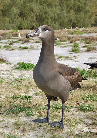 |
| Black Footed Albatross Phoebastria nigripes Photo by: James Lloyd taken on Sand Island, Midway Atoll Febuary 2007 |
Wake Island, to the west of Honolulu, Hawaii, is the northernmost atoll in the Marshall Islands geological ridge and perhaps the oldest living atoll in the world. Though it was substantially modified by the United States to create a military base before and after World War II, its major habitats are the three low coral islands consisting of shells, coral skeletons, and sand, supporting atoll vegetation adapted to arid climate.
Wake Island supports 12 species of resident nesting seabirds and 6 species of migratory shorebirds, including 2 species of tropicbirds, 3 species of boobies, Great Frigate bird, Sooty Tern, Brown Noddy, and Wedge-tailed Shearwater. Black-footed Albatross and Laysan Albatross recently recolonized Wake Island, making it one of the few northern albatross colonies outside the Hawaiian archipelago.
Shallow coral reefs thrive around the perimeter of Wake Island.
Fish populations are abundant and support at least 323 species, including large populations of the Napoleon wrasse (Chelinus), sharks of several species, and large schools of the Bumphead parrotfish (Bolbometapon), all of which are globally depleted. Beyond the shallow reefs, the outer reef slope descends sharply to great depths.
Baker, Howland, and Jarvis Islands were first formed as fringing reefs around islands formed by Cretaceous-era volcanoes (approximately 120-75 million years ago). As the volcanoes subsided, the coral reefs grew upward, maintaining proximity to the sea surface. These low coral islands consist of coral rock, shells, and sand that support trees, shrubs, and grasses adapted to the arid climate at the equator.
All three islands are surrounded by shallow coral reefs to depths of 100 meters, below which the reef slope descends steeply to great depths. Deep coral forests occur below photic zones (the depth of the water that is exposed to sufficient sunlight for photosynthesis) of all three islands at depths below 200 meters, especially at Jarvis where surveys have revealed living colonies of precious and ancient gold coral up to 5,000 years old.
The waters surrounding Baker, Howland, and Jarvis Islands have fish biomass double that of the Papahânaumokuâkea Marine National Monument, and 16 times that of the main Hawaiian Islands, due to the Equatorial Undercurrent that moves from west to east along the equator, creating localized nutrient-rich upwellings in shallows next to the islands. These are three of only six islands in the entire Pacific Ocean where this phenomenon is possible.
These islands are high in coral cover and biodiversity and are predator-dominated systems. Their biomass of top predators exceeds that of the Great Barrier Reef or Kenyan Marine Protected Areas.
The islands now host about a dozen nesting bird species including several nesting and migratory bird species that are of conservation significance. Jarvis alone has nearly 3 million pairs of Sooty Terns. There are about 300 fish species found off the islands. Giant clams (Tridacna), Napoleon wrasses, and Bumphead parrotfish are common, and sharks of many species are especially abundant at Jarvis and commonly larger there than elsewhere.
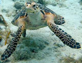 |
| Hawksbill Photo By Caroline Rogers USGS NOAA |
Endangered hawksbill turtle and threatened green turtles forage in near shore waters. All three islands afford unique opportunities to conduct climate change research at the equator, far from population centers.
The coral skeletons there have recorded the earth's climatic history for many millions of years.
Johnston Atoll, the northernmost island in the island chain, is an ancient atoll and probably one of the oldest in the Pacific Ocean. Unlike most atolls, it does not have a surrounding barrier reef but has a semicircular emergent reef around the north and western margins of the island. Four major habitats characterize Johnston: low-lying islets consisting of the remains of corals and shells, shallow coral reefs to depths of 150 meters, deeper reefs to depths of 1,000 meters or more, and the slope of the ancient volcano on which the island rests.
Johnston is a genetic and larval stepping stone from the Remote Islands to the Hawaiian Islands for invertebrates, other reef fauna, corals, and dolphins. Johnston supports thriving communities of Table corals (Acropora) and a total of 45 coral species, including a dozen species confined to the Hawaiian and northern Line Islands.
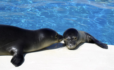 |
| Monk Seal Twins Photo NOAA: The NOAA captive care and release research project seeks to aid recovery of the endangered Hawaiian monk seal. In May 2006, a rare pair of critically endangered Hawaiian monk seal twins—only the fourth set of twins ever documented and the first pair to survive past weaning—was brought to Honolulu from the Midway Atoll National Wildlife Refuge aboard a U.S. Coast Guard C-130 Hercules aircraft. Past observations indicated that twins have a high probability of mortality, and it will be a first if these twins survive and are successfully reintroduced back into the wild. |
Some 300 species of reef fish are at Johnston, including the endemic Nahacky's pygmy angelfish. Many threatened, endangered, and depleted species thrive there, including the green turtle, hawksbill turtle, pearl oyster, giant clams, reef sharks, groupers, humphead wrasse, bumphead parrotfish, whales, and dolphins. Endangered Hawaiian Monk Seals occasionally visit the atoll. Deep diving submersible surveys have revealed that Johnston supports the deepest reef building corals (Leptoseris) on record and large populations of hydrozoan corals (Millepora, Distichopora, Staylaster).
Land areas support large populations of migratory shorebirds and resident seabird species, including populations of regional, national, or international significance: Wedge-tailed Shearwaters, Christmas Shearwaters, Red-tailed Tropicbirds, Brown Boobies, Great Frigatebirds, Gray-backed Terns, and White Terns.
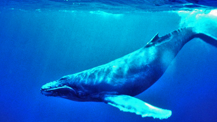 |
| Humpback Whale, Megaptera novaeangliae Photo NOAA |
Approximately 200 threatened green turtles forage at Johnston. The surrounding waters are used by six depleted or endangered listed cetacean species: Sperm, Blue, Sei, Humpback, and North Pacific Right whales. Spinner dolphins are abundant, and endangered Humpback whales may calve there.
Palmyra Atoll is a classic Darwinian atoll that formed atop a sinking Cretaceous-era volcano. Kingman Reef formed in the same manner but is considered an atoll reef because it lacks permanent fast land areas or islands. Kingman Reef contains a sheltered lagoon that served as a way station for flying boats on Hawaii-to-American Samoa flights during the late 1930s. There are no terrestrial plants on the reef, which is frequently awash, but it does support abundant and diverse marine fauna and flora. Palmyra Atoll is managed by the United States Fish and Wildlife Service as a wildlife refuge. In 2001, the Secretary of the Interior established National Wildlife Refuges at Palmyra Atoll and Kingman Reef.
Palmyra Atoll and Kingman Reef are known to be among the most pristine coral reefs in the world, with a fully structured inverted food web. Kingman Reef is the most pristine of any reef under U.S. jurisdiction. They are ideal laboratories for assessing effects of climate change without the difficulty of filtering anthropogenic impacts. Both Palmyra Atoll and Kingman Reef support higher levels of coral and other cnidarian species diversity, 180-190 species, than any other atoll or reef island in the central Pacific, twice as many as are found in Hawaii or Florida.
Palmyra atoll has one of the best remaining examples of Pisonia grandis forest found in the Pacific region. This forest type has been lost or severely degraded over much of its range due to increased human population and development. Fish species diversity at Palmyra, 418 species, is higher than that of the other remote Pacific refuges, while that of Kingman, 297 species, is comparable to their populations.
Many threatened, endangered, and depleted species thrive there, including the green and hawksbill turtle, pearl oyster, giant clams (the highest concentration in the Pacific Remote Island Area), reef sharks, Coconut crabs, groupers, humphead and Napoleon wrasse, bumphead parrotfish, and dolphins. Significant numbers of threatened green turtles forage at both atolls, especially at Palmyra; endangered Hawksbill sea turtles forage at both atolls.
Large schools of rare Melon-headed whales reside off both atolls. A possibly new species of beaked whale was recently described from 2 specimens stranded at Palmyra and 1 at Christmas Island. Palmyra supports 11 nesting seabird species including the third-largest Red-footed Booby colony in the world. Large numbers of Bristle-thighed Curlews, a migratory shorebird of conservation significance, winter at Palmyra.
 |
| Rose Atoll Photo NOAA |
The Rose Atoll Marine National Monument
In the Pacific Ocean approximately 130 nautical miles east-southeast of Pago Pago Harbor, American Samoa, lies Rose Atoll -- the easternmost Samoan island and the southernmost point of the United States. This small atoll, which includes the Rose Atoll National Wildlife Refuge with about 20 acres of land and 1,600 acres of lagoon, remains one of the most pristine atolls in the world. The lands, submerged lands, waters, and marine environment around Rose Atoll support a dynamic reef ecosystem that is home to a very diverse assemblage of terrestrial and marine species, many of which are threatened or endangered.
Few relatively undisturbed islands remain in the world and Rose Atoll is one of the last remaining refuges for the seabird and turtle species of the Central Pacific. Threatened Pisonia atoll forest trees are also found at Rose Atoll.
One of the most striking features of Rose Atoll is the pink hue of fringing reef caused by the dominance of coralline algae, which is the primary reef-building species. Though there are roughly 100 species of stony corals, the shallow reefs are dominated by crustose coralline algae, making them distinctive and quite different from those found at other Samoan islands.
The marine area provides isolated, unmolested nesting grounds for green and hawksbill turtles and has the largest number of nesting turtles in American Samoa. Its waters are frequented by numerous large predators: whitetip reef sharks, blacktip reef sharks, gray reef sharks, snappers, jacks, groupers, and barracudas.
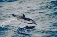 |
| Striped Dolpin Photo: NOAA |
Species that have faced depletion elsewhere, some of which have declined worldwide by as much as 98 percent, are found in abundance at Rose Atoll, including giant clams, Maori wrasse, large parrotfishes, and blacktip, whitetip, and gray reef sharks. Humpback whales, pilot whales, and the porpoise genus Stenella have all been spotted at Rose Atoll. There are 272 species of reef fish, with seven species first described by scientists at Rose and dozens more new species discovered on the first deep water dive to 200 meters. Recent submersible dives around Rose Atoll have revealed abundant marine life, deep sea coral forests, and several new fish and invertebrate species.
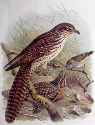 |
| Long-tailed Cuckoo: Shows two long-tailed cuckoos Eudynamys taitensis, the adult on a branch to the left, the chick on the ground receiving a worm from a grey warbler Gerygone igata perched on a branch above it. 1888, From Buller, Walter Lawry. A history of the birds of New Zealand. 2d. ed. Volume I. London, 1888. Plate 14, opp. p. 126, J. G. Keulemans delt. & lith. [Plate XIV, 1888]. |
Rose Atoll supports most of the seabird population of American Samoa, including 12 federally protected migratory seabirds, five species of federally protected shorebirds, and a migrant forest bird, the long-tailed cuckoo.
Rare species of nesting petrels, shearwaters, and terns are thriving at Rose Atoll and increasing in number. The atoll is known to Samoans, who have periodically visited over the past millennium, as "Nu'u O Manu" ("Village of seabirds"). It is believed that Polynesians have harvested at Rose Atoll for millennia and several species, such as the giant clam, were used for cultural celebrations and events.
The information above is from the United States Government News from the White House unless otherwise referenced.
Notes:
Further information is available from these, among other, sources:
Pacific Islands Fisheries Science Center/NOAA
Note:
The New York Times reported in its January 13, 2009, coverage of the newly released book Ocean: An Illustrated Atlas, by Sylvia A. Earle and Linda K. Glover just released (2009) by National Geographic book, Dr. Sylvia Earle “had a hand in President Bush’s designation last week of vast parts of the American-controlled Pacific Ocean as marine monuments. The new protected areas — including the ocean’s deepest spot, down nearly seven miles — are bigger than California.”
See coverage of Ocean: An Illustrated Atlas on the Horizon Solutions Site.
Also see: Horizon's Magic Porthole Coral Reef Web page at www.magicporthole.org